Author Archives: damnilovetraveling

America’s Best Swimming Holes

Standing in the sunshine on the rocky bank, with rivulets of cool water dripping from your hair and swimsuit, you wait your turn at the base of the old oak. You’re up. You grip the fraying rope, get a running start, swing out over the pool of clear water, and release.Cannonball!

In summertime, when the mercury taunts the tip of the thermometer like an angry red fist, the best place to cool down is an old-fashioned swimming hole. These often-secluded natural pools are the perfect antidote to crowded pools with zinc-covered teenage lifeguards or water parks with $8 hot dogs. And they offer a dose of not-yet-forgotten Americana, where sunny days are measured by best friends and belly flops.

Swimming holes are where we shrug off responsibilities and play with the enthusiastic zeal of a child. They’re also places where we come of age.

Pancho Doll, a former writer for the Los Angeles Times, is something of an aficionado. For his first book, Day Trips with a Splash: Swimming Holes of California, Doll logged 25,000 miles in his truck searching the state for the best, from the Oregon state line to San Diego County. He has since penned a whole series that chronicles the best freshwater spots across the country. This is a man who knows a thing or two about taking a dip. “The Holy Trinity of swimming-hole quality is height, depth, and privacy,” says Doll. “Surrounding rock provides a sense of enclosure, often a nice slab inclined for summer repose, even a ledge to jump from.”

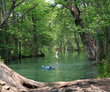
And what says “swimming hole” more than an old-fashioned rope swing? At the cypress-studded Blue Hole in Wimberley, TX, three such swings hang from burly tree limbs. Drop in with the Austinites who come to float on inner tubes and picnic on the grassy banks.

While these natural oases might seem most at home in the South, you’ll find swimming holes across the country. At Peekamoose Blue Hole in New York State’s Catskill Mountains, dappled light bounces off leafy canopies and swimmers submerge themselves in the cool waters like an invigorating summer baptism.

So grab your swimsuit, a towel, and a pair of water shoes, and jump in at some of our favorite swimming holes. Last one in’s a rotten egg!

Swimming Holes Location
 Little River Falls in Little River Canyon National Preserve Alabama

Little River CanyonAL

201006-w-hole-havasupai

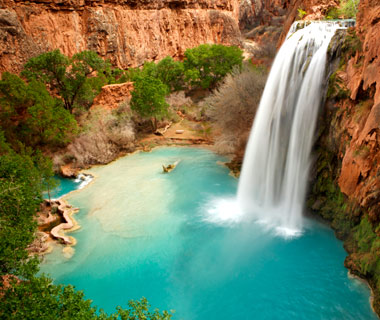
Havasu Falls, Supai, AZ

evergreen_lodge_05

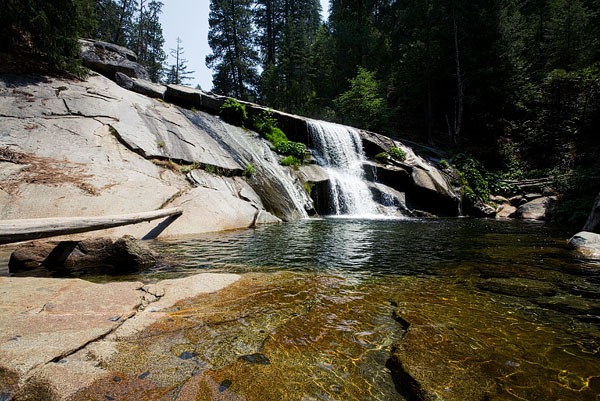
Carlon Falls, Yosemite National Park,CA

Sawtooth National Recreation Area of Idaho where a red canoe is beached on the shores of Little Redfish Lake

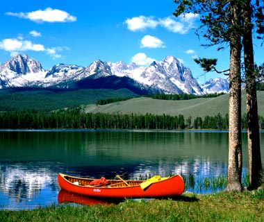
Redfish Lake, Stanley, ID

echo lake

Echo Lake, Mount Desert Island,ME

4379374

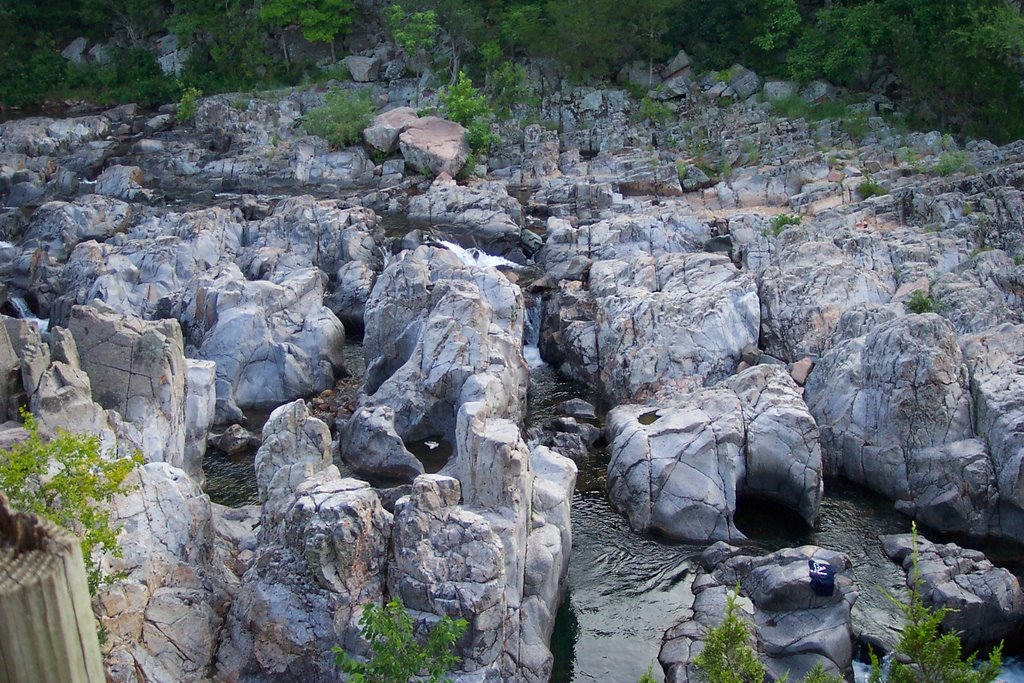
Johnson’s Shut-Ins, ReynoldsCounty,MO

201006-w-holes-peekamoose

Peekamoose Blue Hole, Sundown, NY

73d7fd29766478449288ee85eb771d90

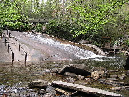
Sliding Rock, Brevard, NC

201006-w-hole-cummins

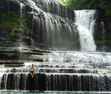
Cummins Falls, Cookeville, TN

201006-w-hole-blue

The Blue Hole, Wimberley, TX


ok.

Categories: North America | Leave a comment

Yellowstone National Park

Yellowstone National Park is the oldest national park in America. It covers an area of 3,472 square miles (8,987 square kilometers) in Wyoming, Idaho, and Montana. It’s an amazing place with deep canyons, tall waterfalls, serene lakes, rolling meadows, and green forests. There are colorful mudpots and spouting geysers (pools of underground water that spew jets of hot water and steam).

hd-yellowstone-park-sign

Yellowstone National Park

Most of the park is a series of plateaus, or tablelands. Rugged mountain ranges rise along the park’s northern, eastern, and western boundaries. The highest point in the park, Eagle Peak, rises over 11,358 feet (3,462 meters) in the east.

The Yellowstone River drains much of the region. The river runs through the Grand Canyon of the Yellowstone, which is 1,200 feet (370 meters) deep in some places. The river has also carved spectacular waterfalls into the rock. Yellowstone Lake is the largest high-altitude lake in North America. It measures about 20 miles (32 kilometers) long and 14 miles (23 kilometers) wide.

Geysers and Hot Springs

Yellowstone has more geysers and hot springs than any other area in the world. These are heated by an underground layer of magma, hot liquid rocks, and gases. The layer is about 2 miles (3.2 kilometers) below the earth’s surface. An explosion of gas and magma about 600,000 years ago created Yellowstone’s rugged landscape.

Morning_Glory_Pool_Yellowstone_National_Park

Geyser

Evidence of this ancient time is present in the park today. At the Fountain Paint Pots, visitors can see hot springs and multi-colored bubbling pools of mud called mudpots or paintpots. The Grand Prismatic Spring is Yellowstone’s largest hot spring. This deep blue pool measures 370 feet (110 meters) across.

The western region of the park contains several geyser basins. Old Faithful, the park’s most famous geyser, is the largest. It erupts every 45 to 110 minutes. Each eruption sends a plume of boiling water 100 to 180 feet (30 to 54 meters) into the air.

Wildlife

Yellowstone is one of the largest wildlife preserves in the United States. Only Alaska has more large and small animals. Hunting is forbidden in the park. Bears, antelopes, coyotes, and buffalo roam the area. Elk are the park’s most commonly sighted animals. More than 30,000 elk live in the park during the summer. In the winter, most migrate to warmer climates.

More than 300 species of birds pass through Yellowstone’s canyons and mountains. Swans, herons, pelicans, and eagles feed on trout and other fish that swim in Yellowstone’s lakes and rivers.

Plant Life

Evergreen forests of fir, spruce, and pine trees cover most of Yellowstone. Pine trees are the most common trees in the park. During the summer months, the mountains and meadows are blanketed with wildflowers. They include Indian paintbrush, monkey flower, and mountain bluebell.

The park also contains over 20 petrified forests. Millions of years ago, volcanic debris buried redwood, walnut, magnolia, and maple trees. Minerals from the mud and water seeped into the trees, turning them into stone over time. Specimen Ridge has some of the most spectacular petrified forests in the park.

What You Will Do

Autumn-to-Yellowstone-national-park.-The-well-known-mountain-falls-the-river-and-forest

Yellowstone National Park Waterfall

Yellowstone is a great place for hikers. There are more than 1,100 miles (1,770 kilometers) of trails winding through the park. Park rangers lead guided hikes and evening campfire programs. There are plenty of campsites, and even cottages, cabins, and hotels.

Fishing enthusiasts love Yellowstone. Fishing is allowed in nearly all of the park’s rivers and streams, but a permit is required. Boats and canoes can be used on most of the lakes in the park. A boat permit is required. During the winter season, heavy snow covers the park. All roads except one are closed. There’s plenty of room for cross-country skiers and snowshoers to enjoy the park’s trails in relative solitude. A plan to provide limited snowmobile and snow coach access began in the fall of 2009. It was to be effective for the following two winters.

Park History

For thousands of years, many Native American tribes crossed the region to hunt for bison and elk. Among them were the Bannock, the Crow, and the Blackfoot. One tribe, the Sheepeaters, lived in what is now the park.

In 1803, the U.S. government obtained the Yellowstone area as part of the Louisiana Purchase. John Colter was the first white explorer to see the region. He arrived on foot in 1807 as a member of the Meriwether Lewis and William Clark expedition. Fur trappers explored the region in the 1830s and 1840s. When the trappers returned home, they told amazing stories of the huge spouting geysers and hot springs they had seen.

Intrigued by their stories, the government sent geologists to map the area in 1871. One year later, Congress passed a bill to establish the park and protect the region’s precious natural resources. President Ulysses S. Grant signed the bill into law, creating the first federally protected national park for the enjoyment of all Americans.

Map

map_yellowstone

Map of Yellowstone National Park

map_of_yellowstone-national-park

Map of Yellowstone National Park

Categories: North America | Tags: , , , , , | Leave a comment

Ayers Rock (Uluru) in Australia

Ayers Rock

Ayers Rock, a huge natural monolith rising 1,100 feet (335 meters) above the surrounding level desert in the heart of Australia. Known as the Rock to Australians, it is sacred to Aboriginals, who call it Uluru.

Measuring about 1.5 miles by 1 mile (2.5 by 1.5 km), the Rock covers 1,170 acres (468 hectares). Situated in the southwestern corner of the Northern Territory, it can be reached by motor vehicle from Alice Springs in four hours. It is basically red conglomerate stone but appears to change in color according to the time of day.

The Rock was named for Sir Henry Ayers, a 19th-century premier of South Australia. It was included in Uluru National Park in 1950, but its ownership was transferred to local Aboriginals in 1985. The Aboriginals then leased the Rock to the Australian government for 99 years.

Climbing

Climbers and Warning Sign

Climbing Uluru is a popular attraction for visitors. A chain handhold added in 1964 and extended in 1976 makes the hour-long climb easier, but it is still a long (800 m/0.5 mi) and steep hike to the top, where it can be quite windy. It is recommended individuals drink plenty of water whilst climbing, and those who are unfit, suffer from vertigo or medical conditions restricting exercise, do not attempt it. Climbing Uluru is generally closed to the public when high winds are recorded at the top. There have been at least 35 deaths relating to recreational climbing since such incidents began being recorded.

The local Aṉangu do not climb Uluru because of its great spiritual significance. They request that visitors do not climb the rock, partly due to the path crossing a sacred traditional Dreamtime track, and also due to a sense of responsibility for the safety of visitors. The visitors guide says “the climb is not prohibited, but we prefer that, as a guest on Aṉangu land, you will choose to respect our law and culture by not climbing.”

On 11 December 1983, Australian Prime Minister Bob Hawke promised to hand back the land title to the Aṉangu traditional custodians and caretakers and agreed to the community’s 10-point plan which included forbidding the climbing of Uluru. The government, however, set access to climb Uluru and a 99-year lease, instead of the previously agreed upon 50-year lease, as conditions before the title was officially given back to the Aṉangu.

In 2009, the Australian government indicated that climbing Uluru may no longer be allowed under the proposed “Draft Management Plan 2009–2019”. The public has been invited to comment on the plan prior to submission to the Minister for the Environment.

Several controversial incidents in 2010, including a striptease, golfing, and nudity on top of Uluru, have led to renewed calls for banning the climb.

Sign informing tourists that the climb is closed due to strong wind

Photography

The Aṉangu also request that visitors do not photograph certain sections of Uluru, for reasons related to traditional Tjukurpa beliefs. These areas are the sites of gender-linked rituals, and are forbidden ground for Aṉangu of the opposite sex to those participating in the rituals in question. The photographic restriction is intended to prevent Aṉangu from inadvertently violating this taboo by encountering photographs of the forbidden sites in the outside world.

Map

Map of Uluru (Ayers Rock)

Uluru (Ayers Rock)

Categories: Asia | Tags: , , , , , | Leave a comment

Machu Picchu

Machu Picchu is the greatest relic of the ancient Inca civilization. It is a town built high in the Andes mountains of Peru. It sits 7,875 feet (2,400 meters) above sea level. And the town is located about 50 miles (80 kilometers) northwest of Cuzco. (Cuzco was the Inca empire’s capital.)

Machu Picchu

The Site

The Inca began building Machu Picchu in the mid-1400s. For a long time no one knew for sure who built it. But today most experts think it was the work of the Inca ruler Pachacuti Inca Yupanqui. The site is believed to have served as a royal retreat.

The most striking feature of Machu Picchu is its architecture. It has about 200 structures, most made of granite. The Inca builders fitted the stones tightly together. In fact, they are so tight that no mortar was needed.

There are several different types of buildings at Machu Picchu. Among them are temples, storage facilities, and houses. A number of the houses are clustered in small groups around central courtyards. Others are set in rows on terraces. Some are two stories tall. The terraces are made of raised banks of dirt. They look like big stairs.

One of the most famous objects at Machu Picchu is a carved stone pillar. It is called Intihuatana, or the “hitching post of the Sun.” Archaeologists believe it was sacred. It was most important to the Inca at the time of the winter solstice. (This is when the Sun is in the sky for the least amount of time.) At that time, a priest would conduct a special ceremony. In this ceremony, he would “tie” the Sun to this post to prevent it from disappearing.

The structures at Machu Picchu are surrounded by large agricultural terraces. These make it look as though the town was carved out of the mountainside. Extensive channels were constructed to carry water to the crops. These included maize (corn) and potatoes.

ancient_city_of_machu_picchu-wallpaper-1366x768

The Town’s Fate

Evidence shows that the Inca did not occupy Machu Picchu for very long. They abandoned it about 100 years after they built it. The exact reasons are uncertain. But most historians think that the inhabitants were wiped out by smallpox. (The Spanish had introduced the disease to Mexico. It had spread southward into Peru and ravaged the Inca.) The Spanish conquerors never knew about Machu Picchu. So they did not destroy it, as they did other Inca cities. Instead, the town eventually became covered by dense jungle. It remained hidden for hundreds of years.

For a long time it was believed that the first modern person to find Machu Picchu was the American archaeologist Hiram Bingham. He found it in 1911. He was searching for another Inca city, Vilcabamba. But new research has pointed to another man, Augusto Berns. This German adventurer may have found the site in 1867 and taken many valuable artifacts. It is also believed that some local people knew about the site.

Machu Picchu Today

During the 1900s, Machu Picchu became very popular with tourists. It was declared a UNESCO World Heritage Site in 1983. (UNESCO means United Nations Educational, Scientific, and Cultural Organization.) And as many as 400,000 visited the site in 2003. However, the Peruvian government fears that erosion is slowly damaging the town. Scientists have studied land movements in the area. In 2001 they warned that the steep rear slope of the site was unstable. It was sliding downward at a rate of about 0.4 inches (1 centimeter) per month, they said. This raised concerns that Machu Picchu could one day be destroyed by a landslide. In April 2004 mudslides killed at least one person at the site. And part of the rail line that carries visitors to and from the town was damaged. In 2007, a new bridge was built to the site. But some people feared more tourists could damage the ruins.

machu-picchu

Categories: South America | Tags: , , , , , | Leave a comment

Ha Long Bay (Heaven on Vietnam)

Ha Long is a large (150,000 ha/370,650 acre) bay to the northeast of Haiphong on the Gulf of Tonkin, in northern Vietnam, containing some 1,600 islands and islets. The islands range enormously in size. A few are sparsely inhabited. Most are rocky outcrops, and many of these have almost vertical slopes. There are many caves and grottoes sculpted by the sea from the stone. The most famous of these is the Hang Dau Go, a large, three-chambered cave that is “the place where the dragon descended into the sea.” The dragon is said to have created the bay and the islands by flailing its tail.

The port city of Hong Gai is situated on the bay. The many archaeological sites that have been found there and along the northeastern coast of Vietnam, have been collectively named the “Ha Long Culture,” a culture that thrived in that region during the Neolithic Period.

In 1962 the North Vietnamese government named Ha Long a national scenic spot and a historical and cultural relict. The bay was named a UNESCO World Heritage Site in 1994.Image

Categories: Asia | Tags: , , , | Leave a comment

Blog at WordPress.com.